— Article
Managing Multi-Team Drone Operations in Large-Scale SAR
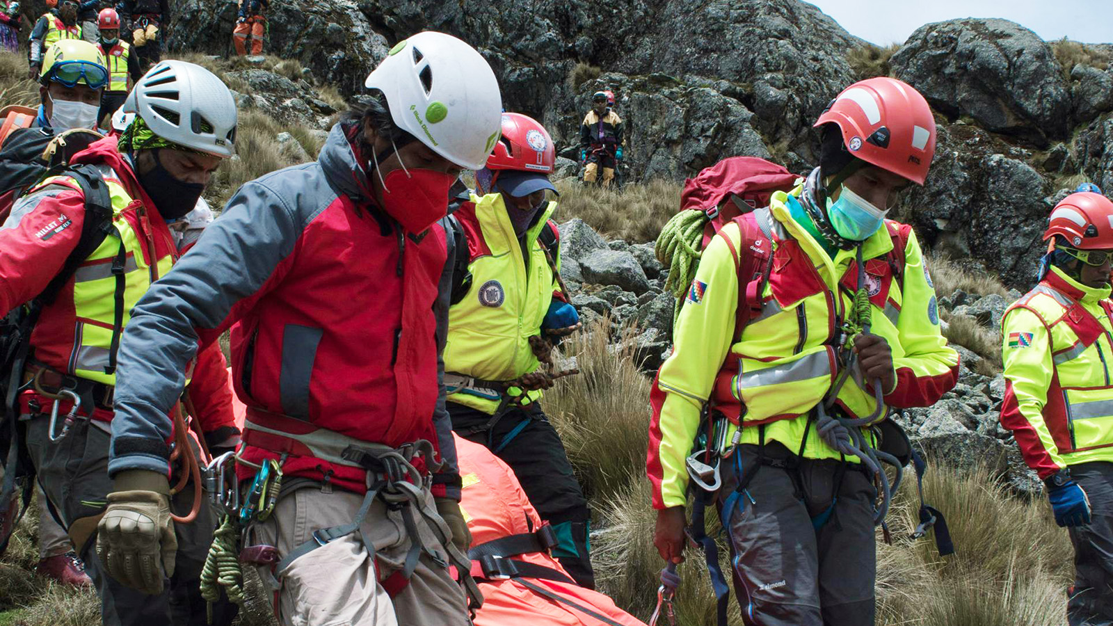
Running one drone on a search is straightforward. Two drones with two pilots gets busier but stays manageable. Three or more aircraft in the air at the same time across a large search area, and the complexity doesn’t just increase. It multiplies.
Most SAR organizations figure this out the hard way. The first time a team tries to coordinate three drone crews across a multi-sector search, the gaps become obvious fast. Radio channels get cluttered. Sector boundaries blur. Nobody is quite sure which aircraft is covering which grid square. One crew runs out of batteries while another sits idle waiting for tasking. The incident commander asks for a coverage update and nobody can give a clean answer.
This is the coordination problem, and it’s the reason that large-scale SAR drone operations need deliberate structure, not just more pilots and more aircraft. This article covers how to organize multi-team drone operations so that adding capacity actually adds capability rather than confusion.
Why Complexity Scales Non-Linearly
The instinct is to think that doubling your aircraft doubles your search capacity. In theory, it should. In practice, it usually doesn’t, at least not until the coordination overhead is addressed.
With a single drone, the pilot talks to the incident commander, flies the assigned area, and reports findings. The communication path is simple and direct. Add a second drone and now you need airspace separation between the two aircraft, a shared understanding of who is covering what, and a way to relay information from two feeds instead of one. Still manageable.
At three or more aircraft, the system crosses a threshold. You now need formal airspace deconfliction (not just “stay on your side”). You need a dedicated person tracking coverage across all sectors. You need a communications plan that prevents crews from talking over each other. You need a battery and crew rotation schedule that keeps continuous coverage without gaps. And you need a way to aggregate findings from multiple feeds into a single picture that the incident commander can actually use.
This is where multi-drone fleet coordination becomes a technology and process challenge, not just a personnel one. The teams that scale successfully are the ones that invest in the coordination layer before they invest in more aircraft.
Sector Assignment: Divide the Search Area Cleanly
The foundation of any multi-team drone operation is clear, unambiguous sector assignment. Every crew needs to know exactly where their search area starts and ends, and those boundaries need to be defined in a way that leaves no gaps and no overlaps.
The simplest approach is geographic sectors divided by terrain features, roads, waterways, or grid coordinates. Each drone team gets a defined polygon and is responsible for completing their assigned search pattern within that polygon. When they finish, they report coverage complete and either rotate to a new sector or stand down for crew rest.
A few things make this harder than it sounds. Terrain doesn’t always divide neatly. A ridgeline might be a natural boundary, but the subject could be on either side of it. River corridors create linear search areas that don’t fit well into rectangular grids. Urban environments have vertical complexity that simple map boundaries don’t capture.
The sector plan should be built during the mission briefing and distributed to all teams before anyone launches. Each crew should have a visual reference showing their sector boundaries, the sectors adjacent to them, and any no-fly zones or altitude restrictions. If sectors need to be reassigned mid-operation (and they often do), there needs to be a clear process for communicating the change to all affected teams, not just the one being reassigned.
One mistake that comes up repeatedly: assigning sectors that are too large for a single battery cycle to cover. If a crew can’t complete their sector on one set of batteries, they’ll land for a swap partway through and lose continuity. Either size sectors to fit within realistic flight endurance (accounting for wind and temperature) or build the handoff point into the plan from the start.
Airspace Deconfliction: Keeping Aircraft Separated
When multiple drones are operating in the same general area, vertical and lateral separation is essential. This isn’t just a safety concern. It’s an FAA compliance requirement and a practical one. A mid-air collision between two of your own aircraft during a search is the kind of incident that shuts down an entire program.
The most common approach is altitude deconfliction. Assign each team a specific altitude block within their sector. Team A flies at 200 feet AGL, Team B at 300 feet, Team C at 150 feet. This provides vertical separation even if flight paths cross horizontally. The altitude assignments should account for the sensor being used. Thermal cameras have an optimal altitude range that balances detection footprint against resolution, so you can’t just stack aircraft at arbitrary altitudes without considering what the sensor can actually see from that height.
Lateral separation is the other option, and it’s what sector boundaries provide. If your sectors are well-defined with buffer zones between them, lateral separation does most of the work. The risk increases at sector boundaries where two crews might be operating near the edge of their respective areas, so briefing crews on boundary protocols is important.
For operations with more than four or five aircraft, or operations where sectors are small enough that aircraft from adjacent sectors could realistically conflict, you need someone dedicated to airspace management. In an ICS structure, this falls under the Air Operations Branch. For teams that have integrated their drone operations into ICS, the Air Tactical Group Supervisor (ATGS) fills this role. For smaller organizations without a formal ICS air ops structure, designating a single person as the airspace coordinator is the minimum.
Communications Discipline: Less Talk, More Signal
Communications breakdown is the number one failure mode in multi-team drone operations. It doesn’t happen because people stop talking. It happens because too many people are talking on the same channel about too many things at the same time.
The fix is structured communications with dedicated channels. At minimum, you need two channels: one for air operations (drone teams communicating with the airspace coordinator or air ops supervisor) and one for the broader incident (drone teams communicating findings to the incident commander or search coordination).
Larger operations benefit from a third channel dedicated to logistics, covering battery swaps, crew rotations, equipment issues, and other support tasks that don’t need to clog the operational frequency.
Within each channel, use sterile cockpit procedures during active search legs. This means only mission-critical communications during the time a pilot is actively flying a search pattern. Status updates, sector completion reports, and target sightings go on the air ops channel. Casual conversation, questions about lunch, and equipment complaints go nowhere until the leg is complete.
Every team should also have a designated communicator. On a two-person crew (pilot plus visual observer), decide upfront who handles radio calls. If the pilot is flying and monitoring the sensor feed, having them also manage radio communications splits their attention at exactly the wrong time. Let the observer handle comms so the pilot can focus on flying and looking.
Pilot Fatigue and Crew Rotation
Fatigue is a silent threat that gets worse as operations extend. A fresh pilot at hour one is sharp, responsive, and making good decisions. That same pilot at hour six is slower to react, more likely to miss a faint thermal signature on the feed, and more prone to making the kind of judgment error that leads to an incident.
For multi-team operations, build a rotation schedule before the first aircraft launches. Define shift lengths based on conditions. Four hours is a reasonable maximum for daytime operations in moderate weather. Night operations, cold weather, and high-stress scenarios should shorten that to two or three hours.
Rotation works best when you have more crews than active flight slots. If you need three aircraft in the air continuously, staff for four or five crews so you always have fresh pilots ready to step in. The crew coming off shift should stand down completely, not just hover around the command post watching feeds and offering unsolicited advice. Real rest means stepping away.
Track flight time per pilot, not just per aircraft. Some platforms can do this automatically by logging who is assigned as PIC for each flight. If you’re tracking this manually, assign someone at the command post to maintain a crew status board showing who is flying, who is resting, who is on deck, and when the next rotation is scheduled.
Fatigue management matters even more during overnight operations when circadian rhythm works against everyone. If your team is running night operations, crew rotation isn’t optional. It’s the single most important safety measure you have.
The Common Operating Picture: Making Sense of Multiple Feeds
The hardest part of multi-team operations isn’t flying the aircraft. It’s synthesizing what they’re finding into something useful. When three or four drones are flying simultaneously, each generating a live sensor feed, no single person can watch all of them at once. And the incident commander doesn’t want four separate reports. They want one answer: what have we covered, what have we found, and where should we look next.
This is where real-time situational awareness becomes more than a buzzword. The common operating picture (COP) is a shared display that shows all active aircraft positions, completed search coverage, points of interest flagged by any crew, and remaining search areas. Everyone from the drone teams to the incident commander should be looking at the same picture.
Building this manually is painful. Someone has to collect sector completion reports from each team, mark them on a map, track which areas still need coverage, and relay that information back out. It works for small operations but falls apart at scale.
A C2 platform that aggregates telemetry from all aircraft into a single map view, tracks coverage in real time, and pushes updates to all stakeholders changes the game entirely. The incident commander sees a live view of which sectors are complete, which are in progress, and which haven’t been touched. The air ops coordinator sees all aircraft positions and can spot potential conflicts before they happen. The search coordinator can reassign sectors on the fly based on what’s actually been covered, not what was planned four hours ago.
This is also where integration with existing dispatch and incident management systems becomes valuable. If the drone COP can feed into the same CAD or dispatch system that the rest of the incident is running on, the drone data becomes part of the overall operational picture rather than a separate information silo that someone has to verbally relay. Our guide to evaluating UAS software for public safety covers what to look for in CAD integration and communications features.
Scaling Up: When Two Aircraft Becomes Ten
The principles above apply whether you’re coordinating three drones or fifteen. But as the number of aircraft increases, the formality of the coordination structure needs to increase with it.
At three to five aircraft, a single airspace coordinator and a structured comms plan are usually enough. At six to ten aircraft, you need a dedicated air operations section with clearly defined roles: an air ops supervisor, sector leads for groups of two or three aircraft, and dedicated logistics support for battery management and crew rotation.
Above ten aircraft, you’re running what amounts to an air operations branch within the ICS structure. This is rare for most SAR organizations, but it happens during major disasters, multi-agency searches, and events where mutual aid brings drone teams from multiple organizations together. At this scale, standardization becomes critical. Everyone needs to be flying compatible equipment, using the same communications protocols, and operating within the same mission planning framework.
The organizations that scale effectively are the ones that build the coordination infrastructure at three aircraft and refine it as they grow. The ones that struggle are the ones that try to improvise coordination at ten aircraft because they never formalized it at three.
The Coordination Layer Is the Capability
More aircraft isn’t automatically more capability. More aircraft with clear sector assignments, disciplined communications, proper airspace deconfliction, fatigue-managed crews, and a shared operating picture is more capability. The coordination layer is what converts additional hardware into actual search coverage.
Invest in the structure before you invest in the next drone. The airframe is the easy part. The hard part, and the part that determines whether your multi-team operation succeeds or devolves into controlled chaos, is everything around it.
We’re building TacLink C2 to be the coordination layer for multi-team drone operations — sector management, fleet-wide telemetry, shared situational awareness, and a single operating picture for every role in the incident. If you’re scaling a SAR drone program past one or two aircraft, join the early access waitlist.
— Related
Keep reading

Written by
TacLink C2 Team
TacLink C2 Team builds a modern desktop ground control station for independent and commercial drone pilots. Writing here covers mission planning, multi-drone operations, airspace, and the software that keeps serious UAS programs running.